Photo Gallery
Here you will find pictures of main characters, various locations described in the story, and additional material not mentioned elsewhere in the text. Scroll down to view all photos. You may also listen to the music played at the Candlemas Dance.
Please click here for artist/photographer credits.
Music from the Series
Click on any title below to hear the song.
Click on any title below to hear the song.
...

Terra Nevaia, the Land of Snow. This is the most habitable and pleasant part of the Moon, partly because of the surrounding seas, which moderate the climate somewhat. Just to the southwest of the Summer Isles, at the very edge of the map, is the location where Neil Armstrong first set foot on the Moon in 1969. Lake Okeechobee is surrounded by mountains and hills - the very high Snowy Mountains (northwest coast), Chocolate Mtns (west), and the much lower Black Hills (east). South of the lake and the Rainbow River are the Southern Wilds, an area of jumbled mountains and crater swamps developed as an area for big-game hunters to go after genetically engineered monsters. The Red Rock Desert is found to the northeast across the Sea of Serenity, and Desolation Island is far to the northwest across the Rainy Sea. The bottom edge of the map, just east of the Stormy Ocean, is the exact center of the Moon as seen from Earth. Terra Nevaia is a long peninsula, of which only the tip is shown here. Rough Scale: 1 inch = 100 miles, or 1 cm = 65 km.

Isles of Venus
Many events took place on Eleuthera, Theia, and Tortuga. The "islands" are really cooler and wetter highlands that rise above the blistering hot and bone dry desert known as the Cytherean Sea because the air is so thick it looks blue from the highlands. The purple shaded areas are the deepest and most dangerous regions. 
Kailua Kona, Hawaii
Formerly the capital of the Kingdom of Hawaii. A few things have changed since then, especially after the eruption of Hualalai in 2100, but it's a very historic city. Many episodes throughout the series occur here. |

Tharsis Region
Most events on Mars take place in this region, within a rough triangle formed by The Redoubt, the Valles Marineris, and the Isle of Xanthe. |

John Brooke Academy for Math and Science
Founded in 2032, the John Brooke Academy for Math and Science sits on one of the highest hills in the the historic Seminole Heights neighborhood of Tampa, on the campus of the former Hillsborough High School. Built in 1928, the building has been meticulously maintained ever since. The Academy has occupied the site since 2057. To the right is the Genetics and Bioscience building, where Tyke did most of his work. The Academy is named for John Mercer Brooke, a prominent scientist and naval administrator of the nineteenth century who was born in Tampa. He was instrumental in the laying of the first transatlantic telegraph cable, and was later a professor at the Virginia Military Institute (VMI).

Front Entrance to the Academy
|

West Entrance to the Academy, near the gym and student dorms where Tyke and Jesse lived. This would have been the entrance they used most often when leaving the campus.
|

Green Sand Beach
Located on the north shore of the largest of the three Summer Isles in the Sea of Tranquility. Green sand beaches are very rare on earth, with the most famous one being located at Papakolea in Hawaii, four miles from South Point on the Big Island. Green sand is formed from the mineral olivine (also known as peridot). It is found in volcanic regions, and the green sand forms because of strong surf action. Olivine grains are heavier than normal sand, and tend to get left behind when regular sand is washed out to sea. This sorting action produces a green beach over time.

Tyke McGrath, jumping 1200 feet into Lake Boscovich from the Bosco Bluffs.
|

Green Sand, closeup
|
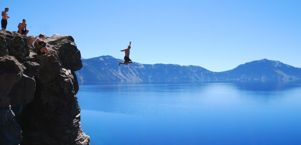
Lake Boscovich. Tyke, Chris, Jesse, Drew, and Danielle jumping into the lake. It's a long way down!

Trinity Bay on the Sea of Serenity, home of many cypress trees and the delectable Blue Hamburger Crab.

Hamburger Crabs, gathered in a plastic bucket at Trinity Bay by Tyke and the others on one of their visits.
|

Rainy Sea. Looking northwest from Barnaby Station. To the left are the White Cliffs below the Snowy Mountains, and a storm is gathering out over the sea.
|

Ukert Springs. The water here is consistently warm and it was partially developed as a tourist attraction, stocked with Doctor Fish and with access facilities.

Shady Lake, in the hills above Lakeside Station. On the far shore is a stand of cottonwood trees common in the sheltered canyons of the Moon. Surrounding the lake are rough hills and cliffs.
|

Doctor Fish at Ukert Springs, nibbling on Tyke's feet.

Shady Lake Cliffs, near where the first jumps were made. Many of these whitestone bluffs exist in the area near Lakeside.
|

Yucca Flats. This area is a few miles west of Lakeside Station and is a flattish area near the Peaceful River. In the foreground are two of the yucca plants for which the place is named. In the distance are the Chocolate Mountains.
|

Yucca Flats, closer to the Chocolate Mountains, so named because of their color. This is not far from the place where Tyke and the others liked to go dune buggy riding.
|

Lightning Storm. These occur regularly on the Moon, especially in late afternoon, and can be very severe. Fires are burning in the distance from earlier strikes from this storm at Yucca Flats.
|

Storm moving in across the hills above the Trinity River valley, just a few miles above Trinity Bay.
|

Lakeside Beach at Lake Okeechobee, with an afternoon wind coming in off the lake.

Creosote Bush, found almost everywhere on the Moon.
|

Golden Poppies, blooming on the hills above Lakeside Station in mid-morning. The bloom only lasts for a day or two each month.
|

West Point, in the Summer Isles in the Sea of Tranquility. This is the westernmost point of the largest of the three islands, and the one on which all the events in the book took place. This is the rockier southern side of the coast. The green sand beaches are on the north shore of this island along the lagoon side. A few coconut palms are visible, which grow nowhere else on the Moon.

East Point, in the Summer Isles. A view of the sunrise.

Grand Canyon of the Moon, between Mount Everbright and Mount Silverspur. Weather like this is common, and very dangerous.

Snowy Mountains, as seen from the upper Faithful Valley.

Emerald Bay water - closeup
|

Red Rock Desert - cliff spires
|
HTML Comment Box is loading comments...